603-723-0480 or 603-723-9604
Canoeing and Kayaking

Lakes and Rivers for Canoeing and Kayaking
Christine Lake

Christine Lake
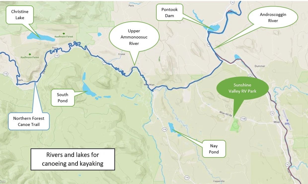
Located in Stark, this lake only has seven houses on it's northwest shoreline. Originally purchased to be a private fishing lake, the State of New Hampshire established public access with a small parking area, boat ramp and public beach on the east end of the lake accessed by Christine Lake Road. This lake can be difficult to paddle on a windy day since the prevailing wind is west to east down the entire length of the lake so go early in the morning before the wind kicks up.
South Pond

South Pond
Located in Stark, this lake is connected to another smaller lake to the north called North Pond by a canal. There are only a few houses on the northern shore of South Pond and the rest of the shoreline and woodlands around the lake is part of the White Mt. National Forest. There are two possible entrances for boat access. On North Pond off Normand Road, there is a small ramp for launching boats, but there is no parking at this ramp so you need to park a few blocks away at the intersection of Normand and Kelly Roads. At the South Pond Recreation area at the end of South Pond Road (open Father's Day to Labor Day) you can launch small boats from the beach and there is ample parking. Both lakes are surrounded by mountains so you can usually canoe or kayak here even in windy conditions by staying close to the shoreline.
Nay Pond

Nay Pond
Located in Milan, this lake has a paved boat ramp with parking located off Nay Pond Road. About half of the shoreline has houses and the rest is in its natural state. The lake is surrounded by hilly terrain so you can usually canoe or kayak here even in windy conditions by staying close to the shoreline.
Pontook Dam and Reservoir

Pontook Dam and Reservoir
Located in Dummer, this reservoir is part of the Ammonoosuc River that backs up behind the Pontook Dam. It has a paved boat ramp with parking located off Rt. 16 in Dummer. From the boat ramp, you can paddle north up the river where there is usually lots of birds and wildlife. The shoreline is all natural and the reservoir near the dam is very open so it can be difficult to navigate in windy conditions.
Northern Forest Canoe Trail

Northern Forest Canoe Trail
The Northern Forest Canoe Trail is a 700-mile water trail from Old Forge, New York to Fort Kent, Maine, that goes through private and public lands. The trail follows traditional travel routes used by Native American, settlers and guides. It is the longest inland water trail in the nation. A section of the Upper Ammonoosuc River running along Rt. 110 in Milan and Stark provides multiple locations for canoeing and kayaking when the river is running high.
This website uses cookies.
We use cookies to analyze website traffic and optimize your website experience. By accepting our use of cookies, your data will be aggregated with all other user data.